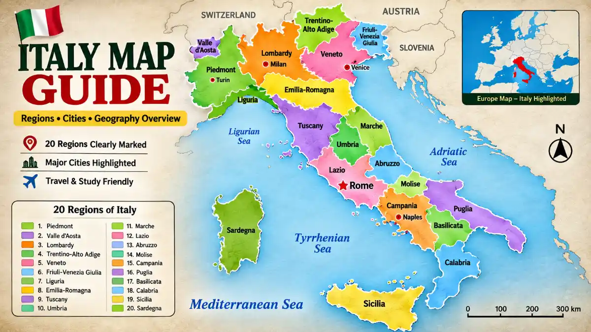

Italy is a boot-shaped country in Southern Europe on the Mediterranean Sea, bordered by France, Switzerland, Austria, and Slovenia. This Italy map guide covers all 20 regions, major cities, and the terrain that shapes the country, along with the islands of Sicily and Sardinia and hundreds of smaller islands scattered along its coasts.
Italy Map Labeled: Regions and Cities
This political map labels Italy’s 20 regions in distinct colors alongside their capital cities and the seas bordering the peninsula on three sides – the Tyrrhenian, Adriatic, Ionian, and Ligurian. Each region carries its own capital, marked as the largest labeled point within its colored boundary, while national borders with France, Switzerland, Austria, and Slovenia run along the northern edge.
Quick Facts Table
| Attribute | Detail |
| Coordinates | 35°N–47°N, 6°E–19°E |
| Total area | 301,340 km² (116,350 sq mi) |
| Population | Approximately 58.9 million |
| Capital | Rome |
| Regions | 20 (5 autonomous) |
| Highest point | Mont Blanc, 4,810 m |
| Longest river | Po River, 652 km |
| Land borders | France, Switzerland, Austria, Slovenia |
| Enclave states | San Marino, Vatican City |
| North-south length | Approximately 1,200 km |
How to Read an Italy Map
Reading a map of Italy accurately depends on knowing which layer you’re looking at – political, elevation, or distance-based – since each tells a different story about the same territory.
- Regions vs. provinces: Political maps color-code the 20 regions; provinces form a smaller second tier shown only as thin internal lines within each region, so avoid mistaking a provincial border for a regional one.
- Elevation vs. political view: A political layout shows administrative borders and cities, while a physical map shows the Alps and Apennines as shaded terrain – the physical view is what actually tells you how mountainous a route will be.
- Distance vs. travel time: Straight-line distance can mislead in Italy, since mountainous terrain in the Apennines or narrow coastal roads often makes real travel time longer than map distance suggests.
- Islands in inset boxes: Sicily and Sardinia frequently appear in separate inset boxes for space reasons, which distorts how far they actually sit from the mainland – in reality, hundreds of kilometers offshore.
Italy’s Administrative Hierarchy: Regions, Provinces, Comuni
Italy’s territory is organized in three nested administrative layers.
| Level | Count | Function |
| Region (Regione) | 20 | Top-level government, healthcare, regional laws |
| Province/Metro City | ~107 | Local infrastructure, inter-town coordination |
| Comune (Municipality) | ~7,900 | Local government, civil registry, town services |
Read More: Italy Map
A region like Tuscany contains multiple provinces, such as Florence, Siena, and Pisa, and each province is made up of individual comuni – the smallest administrative unit, roughly equivalent to a town. This hierarchy explains why a city name can appear at two different levels on a detailed map: once as a comune, and again as the capital of its surrounding province.
Italy in Europe
Positioned in Southern Europe, Italy sits between latitude 35°N and 47°N and longitude 6°E and 19°E, forming a peninsula that extends into the central Mediterranean Sea. It borders France to the west, Switzerland and Austria to the north, and Slovenia to the northeast, with the microstates San Marino and Vatican City sitting entirely within Italian territory rather than along an external edge.
Within Europe, Italy ranks as the tenth-largest country by area – smaller than France, Spain, and Germany but larger than the United Kingdom.
Northern Italy Map vs. Southern Italy Map
| Zone | Regions | Geography |
| North | Lombardy, Piedmont, Veneto, Emilia-Romagna, Liguria, Friuli-Venezia Giulia, Trentino-Alto Adige, Valle d’Aosta | Alps, Po Valley, industrial core |
| Center | Lazio, Tuscany, Umbria, Marche, Abruzzo | Apennine hills, capital region |
| South (mainland) | Campania, Puglia, Calabria, Basilicata, Molise | Coastal plains, volcanic zones |
| Islands | Sicily, Sardinia | Mediterranean island terrain |
The northern zone centers on the flat, industrialized Po Valley, with a continental climate and the country’s highest concentration of wealth. The south, by contrast, is dominated by mountainous, coastal terrain with a Mediterranean climate, stronger regional dialects, and generally lower living costs. This divide also explains why standard Italian dominates official use in the north while dialects like Neapolitan and Sicilian remain deeply rooted in the south.
Autonomous Regions
Five regions – Sicily, Sardinia, Friuli-Venezia Giulia, Trentino-Alto Adige, and Valle d’Aosta – hold special autonomous status, giving them greater control over local taxation and administration due to island geography or linguistic minorities, such as the German-speaking population in South Tyrol.
Italy Physical Map: Terrain and Water Features
Italy physical map
Nearly 40% of the country is mountainous. The Alps form the northern border, stretching roughly 1,000 kilometers, and contain Mont Blanc (4,810 m), Italy’s highest point. The Apennine Mountains run about 1,200 to 1,350 kilometers down the peninsula’s spine, continuing beneath the Strait of Messina into Sicily, where Mount Etna rises as Europe’s most active volcano. Near Naples, Mount Vesuvius marks another significant volcanic feature. Between the Alps and the Apennines lies the Po Valley, the largest flat, fertile plain and the country’s most industrialized region.
| Feature | Length/Size | Location |
| Po River | 652 km (longest) | Alps to Adriatic Sea |
| Adige River | 410 km | Northeast Italy |
| Tiber River | 405 km | Through Rome |
| Arno River | 241 km | Through Florence, Pisa |
| Lake Garda | Largest lake by area | Northern Italy |
| Lake Como | Known for lakeside villas | Lombardy |
Map of Italy with Cities
| Rank | City | Region | Role |
| 1 | Rome | Lazio | National capital |
| 2 | Milan | Lombardy | Finance, fashion |
| 3 | Naples | Campania | Southern port |
| 4 | Turin | Piedmont | Automotive, industry |
| 5 | Palermo | Sicily | Largest city on the island |
| 6 | Bologna | Emilia-Romagna | University, food |
| 7 | Florence | Tuscany | Renaissance art |
| 8 | Venice | Veneto | Canal city |
| 9 | Bari | Puglia | Adriatic port |
| 10 | Genoa | Liguria | Maritime port |
Read More: Italy Map
Italy Tourist Map: Regional Circuits
Most travel planning centers on Lazio, Tuscany, Veneto, Campania, and Sicily, connected by high-speed rail. The “Golden Triangle” of Rome, Florence, and Venice remains the most-searched route, while the Amalfi Coast, Cinque Terre, and the Dolomites offer coastal and alpine alternatives for travelers building a broader itinerary.
Italy Size Comparison: How Big Is It Really?
| Comparison | Italy | Other Region | Difference |
| vs. United Kingdom | 301,340 km² | ~243,600 km² | Italy is ~24% larger |
| vs. Arizona (USA) | 301,340 km² | ~294,312 km² | Italy is ~2% larger |
| vs. Germany | 301,340 km² | ~357,580 km² | Germany is ~19% larger |
| vs. Metropolitan France | 301,340 km² | ~551,500 km² | France is ~83% larger |
Seeing Italy next to Arizona or the UK gives a quick mental anchor: it’s a mid-sized European country, notably smaller than France or Germany but larger than most people assume when viewing it on a small world map.
Political vs. Physical vs. Tourist Maps
| Map Type | Primary Use | Key Features |
| Political | Administrative reference | Regional borders, capitals |
| Physical | Terrain planning | Mountains, rivers, elevation |
| Tourist | Trip planning | Attractions, transport routes |
Choosing the right one depends on your goal – a road trip through the Apennines calls for a physical view, while researching the country’s regional government structure calls for a political layout.
Frequently Asked Questions
What does an Italy map look like?
It shows a boot-shaped peninsula extending into the Mediterranean Sea, with 20 color-coded regions, the island of Sicily near the “toe,” and Sardinia positioned further west. Political versions label regional capitals and borders, while physical versions show the Alps in the north and the Apennine Mountains running down the center.
Where is Italy located on the world map?
Italy sits in Southern Europe between latitude 35°N–47°N and longitude 6°E–19°E, extending as a peninsula into the central Mediterranean Sea. It borders France, Switzerland, Austria, and Slovenia to the north, with Sicily and Sardinia as its major islands.
What countries surround Italy?
Italy has land borders with France, Switzerland, Austria, and Slovenia, plus the enclave states San Marino and Vatican City entirely within its territory. Its coastline touches the Tyrrhenian, Adriatic, Ionian, and Ligurian Seas.
How do you read an Italy regions map?
Match each color block to its labeled region name and locate the capital city marker within it, since political maps typically color-code all 20 regions separately. Provinces, a smaller administrative tier, usually appear only as thin internal lines rather than separate colors.
What is the difference between Italy’s regions and provinces?
Regions are the top-level administrative divisions, 20 in total, each with its own regional government. Provinces are a smaller second tier within each region, roughly 107 in total, handling local infrastructure, while comuni are the smallest unit, functioning as individual towns or municipalities.
What is the difference between Northern and Southern Italy?
Northern Italy covers the industrialized Po Valley and Alpine regions with a continental climate, while Southern Italy is mountainous and coastal with a Mediterranean climate and stronger regional dialects. The divide also reflects differences in cost of living, economy, and infrastructure density.
How many regions does Italy have?
Italy has 20 regions, five of which – Sicily, Sardinia, Friuli-Venezia Giulia, Trentino-Alto Adige, and Valle d’Aosta – hold special autonomous status due to island geography or linguistic minorities.
Is Italy bigger than the UK?
Yes, Italy covers about 301,340 km², roughly 24% larger than the United Kingdom’s 243,600 km², despite the UK having a larger population.
How big is Italy compared to a US state?
Italy is almost identical in size to Arizona, at about 301,340 km² versus Arizona’s 294,312 km², making it roughly 2% larger.
What is the highest point in Italy?
Mont Blanc, at 4,810 meters, sits on the France-Italy border in the Alps, while Gran Paradiso (4,061 m) is the highest peak located entirely within Italian territory.